- Salt Creek Fire Contained
|
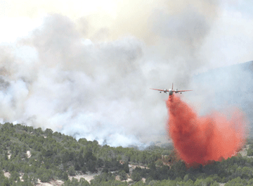
RETARDANT DROP • A plane dropps fire retardant east of Nephi last week. As of Sunday, the fire is said to be 90% contained Photo J. Michael Johnson, National Park Service
By Myrna Trauntvein
Times-News Correspondent
On Sunday, the Salt Creek Fire was considered contained and the Type I Southern Area Incident Management Team with Mark Ruggiero, as incident commander, transferred command of the Salt Creek Fire back to local jurisdictions on July 29 at 6 p.m.
“We estimate containment at 90 percent today,” said Ruggiero on Sunday.
Rain showers have helped to cool everything off and give firefighters a chance to get the upper hand on the 10-day fire.
The fire started July 19, five miles east of Nephi along State Route 132.
“The fire then burned north and south of the highway,” said Terry McDonald, fire information officer.
The fire also spread to the northeast in the direction of Indianola Valley.
Salt Creek Fire, named for the location of its origin, burned in both Juab and Sanpete Counties.
The estimated acreage 25,456 acres (Sanpete County: 10,566 acres and Juab County 14,890 acres).
McDonald said the estimated cost of fighting the fire, to date, is $3,844.522.
Resources on Fire: 2 helicopters; 52 engines; 6 bulldozers; 13 water tenders; and 5 hand crews.
“On Saturday,” he said, “we were able to have a total of 465 personnel on the fire. That was a big factor in addition to the lower temperatures.”
In addition, he said, before the rain came to the Fountain Green end of the fire, firefighters were able to finish the backburn.
“It rained on the Nephi side,” said deputy assistant fire commander Tom Speaks. “For a short while we thought we had lost it because the wind from the storm blew up the canyon. But we held the line.”
Rain, increased humidity and additional workers helped knock the fire down over the last few days.
Crews will continue work for days to ensure that the fire remains in control, said fire information officer Mike Johnson.
Residences would have been incinerated but for backfires and aerial bombardments. However, said McDonald, the first concern in fighting a fire is safety of humans and second is the protection of property.
Emergency-response incident teams will now work to reseed the burned area and take steps to stop problems such as flooding and debris in streams.
“We are already working to cut down the burned cottonwoods along the Nebo Loop road,” said Doug Jones, Unita National Forest District Ranger for the Spanish Fork Ranger District.
Resources were slow in coming to Salt Creek because of the many fires burning in the West.
The USDA Forest Service, State of Utah, Utah Department of Natural Resources, Utah Highway Patrol, Bureau of Land Management, Juab County, Sanpete County and Utah County all cooperated in working to put out the blaze.
State Route 132 is open. It was opened on Tuesday, July 24, at 9 a.m. to accommodate the holiday traffic.
“I would have liked to have opened it sooner,” said Jones. “However, as we discussed it, it was decided that for safety reasons it was too early to open the road before Tuesday.”
Big Hollow Road and Water Hollow Road remain closed.
The Nebo Loop National Scenic Byway is closed from the intersection of the Loop Road with the Santaquin Canyon Road and south to Salt Creek Canyon. The Nebo Loop is open from Payson to the intersection with the Santaquin Canyon Road. That includes Blackhawk and Payson Lakes Campground and Maple Dell Boy Scout Camp.
Santaquin Canyon is open and includes Tinney Flat Campground and Camp Koholowo.
The Uinta and the Manti La-Sal National Forests have implemented emergency fire closures on portions of the National Forests north and south of State Route 132 in the vicinity of the fire. Roads and trails affected: Uinta National Forest—Nebo Creek Road (Forest Road (FR #045)), Nebo Loop Road (FR #015), and trails on the south end of the Nebo including 106, 084, 130 and all other wilderness trailheads will be closed. Manti-La Sal National Forest Rocky Ridge Canyon Road (FR #154), Log Hollow Road (FR #069), and Red Cliff Road (FR #127) will be closed.
Fire restrictions remain in place. No campfires are allowed on any lands in Utah outside of developed, designated campgrounds. Barbecues and charcoal are prohibited. Propane stoves are permitted. Fireworks are prohibited on federal and state land. Smoking is prohibited, except within an enclosed vehicle or building, a developed recreation site, or while stopped in an area at least three feet in diameter that is free of all flammable materials.
Fire fighting resources continue mop up, ensuring there is no heat up to 150 feet deep into the burn.
Heli-repellers will continue constructing handline in the high country.
“Excavators, dozers, and hand crews are focusing on fire suppression rehabilitation, including installing water bars to help minimize erosion; pulling soil, organic debris and rock back onto areas cleared as fireline to blend them in with the surrounding terrain; and restoring brush, berms and rocks that were cast aside when safety zones and other areas were cleared,” said McDonald.
A Burned Area Emergency Response Team is also assigned to the fire area.
Engine crews are prepared for initial attack of any new starts in and around the fire. Fire fighting resources are improving fireline.
The Temporary Flight Restriction was lifted at noon Sunday.
Fire weather is forecast at mostly sunny to partly cloudy with scattered afternoon showers or thunderstorms. Temperatures are predicted at ranging from 85-95 degrees with slightly lower relative humidity between 12-19 percent.
“Fits of gusty erratic winds to 45 mph and lightning will remain the main threat with storms,” said McDonald. “Brief heavy rains, with flash flooding and debris flows are possible.”
“On the fire, no hot spots were identified during last night’s infrared flight,” he said.
However, fuels in the local area are beginning to dry out and potential for ignition of new starts is increasing.
The goal of Suppression Rehabilitation is to mitigate the impacts of suppression activities.
This includes rehabilitation of firelines, dirt roads, and other areas, where soil was pushed, scraped, or plowed. Objectives of fire suppression rehabilitation include: Minimize/prevent surface and gully erosion; Minimize/prevent sediment from getting into channels; Restore drainage pattern in stream courses if altered by dozers; Repair damage done to private property; and Leave the area clean and remove trash, flagging, signs, etc.
“An influx of precipitation over the past few days has had a significant and major impact on fire activity and has given suppression resources an opportunity to make significant progress,” said. Ruggiero.
The major cost of the fire has amounted to “structure protection.” In this fire, resources were spent on protection of scattered dwellings and homes of urban citizens.
Power crews have also been finishing up repairs to the two major power lines in the area.
|